Ben Wyvis

9.8.04 - Achnashellach Trip, Day 1 - 18km, 1030m - 343 mins

Area 15: Ben Wyvis and the Deargs

< Previous | Walk 46 | Next >
Ben Wyvis1046m3432ftM85#107
Click here or on any picture to switch to slideshow
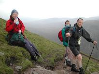
A rest stop near the top of the ridge

For our summer jaunt of 2004, Isdale, Alasdair and Howard and I had planned a week based at Achnashellach in Glen Carron. They all arrived in Dunblane on Sunday 8th August in the evening. The following morning we managed to be up early and were away by 8.15. The weather forecast for the week was pretty poor, in particular there were to be thunderstorms and torrential rain that day up the whole of the west coast. We had abandoned our initial plan, therefore, to do the Aonach Eagach, and had decided to head for the only bit of the country with a half-decent outlook - the far north-east. It was raining as we left Dunblane but we were soon out of this and into clear skies and even some sunshine. We stopped off in Inverness, where we bought our food for the week in Safeways. Alasdair had suggested Ben Klibreck for that day, but this was rather far out of our way, and I had already done it, though a long time before. Instead we settled on Ben Wyvis, which Alasdair had done, but not the rest of us. The only problem was we had no map for it, so Howard sprinted off to find one. We drove the half hour or so to Garbat while the skies clouded over.

Ben Wyvis was cloudy but the ridge was visible at this stage. By the time we’d had lunch by the cars, however, and set off about 1.30, the summit was in cloud. The path (recently 'rebuilt by the Footpath Trust' according to an inscription near the start) was excellent all the way to the top. As we walked up beside the stream it started to spit with rain, then got heavier. Eventually we were trudging along in pretty heavy rain, meeting several parties coming the other way who obviously thought we were crazy. The going was pretty good though on the zigzag path up the steep slopes, and soon the rain fizzled out.

At the summit of An Cabar

As we reached the first top (An Cabar) it was clear and we could see views coming and going through passing mist. We pressed on and were soon into solid mist for the rest of the walk along the ridge. At the summit we debated whether to simply head back down the excellent path (Alasdair's preference) or continue on to the second top and return by a pathless route (Isdale's preference). In the end Isdale persuaded us by showing on the map that the distance via the second top was actually no more than the straight return journey - one up for the toppers!

A hazy view during the descent

So we continued on, descending quite steeply, then climbing again to Tom a'Chòinnich. Here the path ended and we headed off on a bearing, all four of us with compasses out. It was steep at first, then we came out of the mist and could see the shoulder sweeping down to the forest below. There followed a long tramp down over the pathless and increasingly boggy hillside till we reached the edge of the forest. Howard, who was well ahead, scouted out a likely looking firebreak which we followed, taking several turns, until we reached a track which we'd crossed on the way up. This took us back to the path and we were at the cars by 6.45, defying Cameron McNeish who for some reason gives the estimated time for this trip as '6-10 hours'!

There were midges aplenty at the car park so we left as quickly as possible, heading down the very fast almost empty road to Achnashellach and "Gerry's Hostel" which was to be our base for the week. There was no Gerry when we arrived, but there was a party of five Germans - surely this wasn't what it meant by "Gerry’s Hostel"?? There were also plenty of midges here, mostly outside but trying their best to get in. Alasdair cooked a meal for us, the enigmatic Gerry appeared eventually, and I was in bed by 10 - amazing!